


Ulysses Precinct, Butler County, Nebraska
About
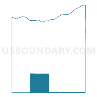
Outline

Summary
| Unique Area Identifier | 612507 |
| Name | Ulysses Precinct |
| County | Butler County |
| State | Nebraska |
| Area (square miles) | 36.24 |
| Land Area (square miles) | 36.10 |
| Water Area (square miles) | 0.14 |
| % of Land Area | 99.60 |
| % of Water Area | 0.40 |
| Latitude of the Internal Point | 41.09323330 |
| Longtitude of the Internal Point | -97.18856970 |
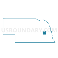
Maps

Graphs
Select a template below for downloading or customizing gragh for Ulysses Precinct, Butler County, Nebraska


Neighbors
Neighoring Voting District (by Name) Neighboring Voting District on the Map
- B Precinct, Seward County, NE
- C Precinct, Seward County, NE
- Center Precinct, Butler County, NE
- Plum Creek Precinct, Butler County, NE
- Read Precinct, Butler County, NE
- Reading Precinct, Butler County, NE
- Union Precinct, Butler County, NE
Top 10 Neighboring County Subdivision (by Population) Neighboring County Subdivision on the Map
- Reading township, Butler County, NE (521)
- Precinct C, Seward County, NE (491)
- Precinct B, Seward County, NE (420)
- Ulysses township, Butler County, NE (323)
- Union township, Butler County, NE (211)
- Center township, Butler County, NE (200)
- Read township, Butler County, NE (181)
- Plum Creek township, Butler County, NE (139)
Top 10 Neighboring Place (by Population) Neighboring Place on the Map
Top 10 Neighboring Unified School District (by Population) Neighboring Unified School District on the Map
- Seward Public Schools, NE (10,431)
- David City Public Schools, NE (5,676)
- Centennial Public Schools, NE (3,378)
- East Butler Public Schools, NE (1,902)
- Rising City Public Schools, NE (609)
Top 10 Neighboring State Legislative District Upper Chamber (by Population) Neighboring State Legislative District Upper Chamber on the Map
Top 10 Neighboring 111th Congressional District (by Population) Neighboring 111th Congressional District on the Map
Top 10 Neighboring Census Tract (by Population) Neighboring Census Tract on the Map
Top 10 Neighboring 5-Digit ZIP Code Tabulation Area (by Population) Neighboring 5-Digit ZIP Code Tabulation Area on the Map
- 68434, NE (8,576)
- 68632, NE (3,989)
- 68658, NE (683)
- 68635, NE (491)
- 68439, NE (478)
- 68669, NE (422)
- 68667, NE (92)